The Annapurna Region lies towards the northern part of Nepal, renowned as one of the world’s preeminent trekking destination, it escorts you through rhododendron forests and over the foothills of Annapurna and Dhaulagiri mountains. Annapurna Circuit Trekking gives you awesome views of the peaks Annapurna I, II, III, IV, Dhaulagiri (the spectacular ice pyramid) and Machhapuchhre (fish tail), and those of Annapurna South.
This trekking is the most rewarding way to experience Nepal’s natural embellishment and cultural assortment walking along through the forest of rhododendrons, isolated hamlets, small mountain villages, birds, animals, breathtaking landscapes, you will also encounter friendly and warm hearted people of different cultures offering a fascinating glimpse of traditional rural life.
The Annapurna region is reached via Pokhara, which is 200 kilometers from Kathmandu. It is six hours by road and 30 minutes by air from Kathmandu.
Trip Name
Annapurna Circuit Trek
Trip Duration
15 Nights / 16 Days
Difficulty Level
Medium
Altitude
Best Season
Trip Start From
Trip Ends At
Detailed Itinerary
Day 1
Drive Kathmandu to Chamje (1410m .) 9 hours drive
The route follows the Marsyangdi River upstream, crossing a long suspension bridge and passing a beautiful, thin waterfall with a fine bathing pool. We ascend to the town of Bahundanda, which means ‘Brahman Hill’. There are good views to the north and a little-known hot spring here.
The gorge becomes narrower as we cross a cantilever bridge followed by a suspension bridge. We pass a few small settlements along the route and Chamje, the destination for the day, is one of them. Having travelled upstream, we observe many changes in the people, architecture and vegetation. Houses are now built of rocks, the vegetation is less tropical and the culture more Tibetan-like. Overnight at Lodge .(L,D)
(B,L,D)
Day 2
Trek Chamje to Dharapani (19400m .) 6 hours
Today we enter the Manang region passing through fields of corn, barley and potatoes and then through forests of bamboo and rhododendrons. On the way in the village namely Tal. Tal lies on a flat plain next to the beach and river at the base of a large waterfall. While we are hiking, sometimes we may have to give a pass to a large group of donkey caravan. Overnight at Lodge in Dharapani
(B,L,D)
Day 3
Trek Dharapani to Chame (2710m .) 6 hours
Leaving Dharapai, the gorge becomes more impressive. We cross into the district of Manang and see more Bhotia people. These are primarily agro-pastoralists and the real trans-Himalayan traders of the region. The route climbs gradually to the town of Bagarchap meaning (butcher’s place). The houses here have flat roofs, indicating that there is less rainfall here than the south. There is a temple here worth visiting, and views of the Annapurnas and the Lamjung Himal.Overnight at Lodge.
(B,L,D)
Day 4
Chame - Pisang(3133m)
We continue in an unrelenting narrow valley of pine, hemlock and cypress forest. The trail through a serene forest leads to lower Pisang; a side trip to higher Pisang (100m higher) is a must for an amazing view of Annapurna II. This arid region is in the rain shadow of the Himalaya. The men here are traders - and may sell or trade almost anything - and part-time farmers, and the women are full-time farmers. Overnight at Lodge .
(B,L,D)
Day 5
Pisang – Manang (3500m) 6-7 hours
There are 2 routes from here: a low road and a high road, the latter taking longer but affording outstanding views of the Annapurna Himal and few trekkers. Both routes converge in the large and interesting village of Braga, which is the seat of the oldest monastery in the area. The gomba is about 900 years old and belongs to the Kargyupa sect of Tibetan Buddhism, and contains some unique works of art. Manang is 30 minutes from here.Overnight at Lodge
(B,L,D)
Day 6
Explore Manang village (3500m)
Today is acclimatization day, which is best spent being active and climbing to higher elevations for views but returning to lower altitudes to sleep. Manang itself is in a spectacular location with many attractions. There are lakes, caves, moraine-hills, monasteries or local activities in town. Overnight at Lodge
(B,L,D)
Day 7
Manang - Latdar(4176m)5 hours
Leaving Manang, facilities become scarcer. We cross small tributaries and contour along pleasant meadows with occasional birch groves. There is a chance to see herds of blue sheep. Overnight at Lodge
(B,L,D)
Day 8
Latdar - Thorung Phedi(4450m) 4 hours
We gain altitude gradually, and spend the night at the phedi, meaning 'foot of a hill'. If you are lucky you may spot a snow leopard near here at dusk! Overnight at Lodge
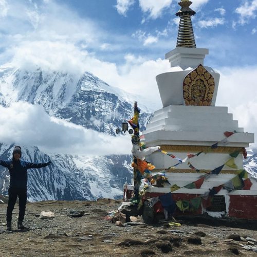
The trail now leaves the river valley and climbs steadily over lateral moraine. The pass, marked by a large cairn, is the high point of our trek. It is an exhilarating geographical feature, dividing 2 mighty Himalayan valleys. Far below to the west is the Kaligandaki River. We descend in that direction for the village of Muktinath, located in a poplar grove. It is a sacred shrine and pilgrimage site for Hindus and Buddhists. Overnight at Lodge
(B,L,D)
Day 10
Muktinath - Jomsom(2713m) 5 hours
From Muktinath to Jomsom, we see people from Mustang, a restricted area to the north, who come to sell handicrafts to pilgrims. Among their merchandise is the highly-revered mollusk fossil called shaligram. We will pass some ancient caves and see the impressive white mountain that is the Dhaulagiri. We also transit at the significant town of Kagbeni, which is at a junction of 2 rivers and the north-south and east-west trading routes. Overnight at Lodge
(B,L,D)
Day 11
Jomsom - Kalopani(2530m) 6 hours
We descend to Marpha, a lovely village of whitewashed houses and fertile fields, and continue down the Kaligandaki reaching the former Thakali trading centre of Tukche. As the trail continues, the Himalayan rain shadow blends into coniferous forest,and we reach the main river valley and Kalopani. From here there are spectacular views of Dhaulagiri and the Annapurnas. Overnight at Lodge
(B,L,D)
Day 12
Kalopani - Tatopani(1190m) 6 hours
A beautiful walk, with another transition into sub-tropical vegetation and the return of water buffalo, banyan trees and poinsettias. The trail follows the river through a narrow gorge and descends to cross a bridge near a spectacular waterfall,before winding through the valley to Tatopani. The hot springs that give the village its name provide the perfect opportunity for a good scrub. Overnight at Lodge.
(B,L,D)
Day 13
Tatopani - Ghorepani(2819m) 6 hours
Steadily climbing all day, we eventually leave behind the terraced fields and walk through thick rhododendron forest to the village of Ghorepani, meaning (horse water). We camp at the pass for the best views of the sunset over the spectacular,snow-capped Dhaulagiri and the Annapurna Range. Overnight at Lodge
(B,L,D)
Day 14
Ghorepani - Tadapani (2710m) 6 hours
Today the trail undulates through giant rhododendron forest and orchid colonies to the pretty Gurung town of Ghandrung,where the Annapurna range and Machapuchare (the Fishtail) dominate the mountain views, although glimpses of Lamjung Himal and the Manaslu range can also be seen further east. Overnight at Lodge
(B,L,D)
Day 15
Tadapani – Ghandurk (2012m) 3 hours
Served the breakfast in the morning and start your journey, 8:00 am to Landruk, it takes approx 6 hours . From Tadapani, the trails descends through the forests then terraced fields, to the Khummu Khola. The Ghandruk trails descends steeply from Tadapani,through forests, a short steep descend among rocks lead to a stream crossing, then the descent continues gently past over streams, finally leading out on the ridge to Ghandruk.
Ghandruk a huge Gurung village at 1940 meters, is the second largest Gurung village in Nepal and is a confusing cluster of closely-spaced, slate- roofed houses. There are neatly terraced fields situated both above and below the town. It is wonderfully easy to get lost in the network of narrow alleyways while trying to trek through the village. There is a larger handicraft factory at the top of Ghandruk. The views of Annapurna south from here are out standing. Machhapuchhare, seen from here in its fish tail aspect, peeps over a forested ridge. ACAP has visitor centre and an office in Ghandruk and provides offers information about it activities. Overnight at Lodge
(B,L,D)
Day 16
Ghandruk to Nayapul and drive to - Pokhara
After breakfast, we will leave the village and walk down on the stone paved stone staircase for a while and viewing Landruk village just opposite side of us. After a two hours walk down from Ghandruk village, we arrive in Syaulibazar. Then, we will follow the plain dusty road way along the Modi Khola until reaching Birethanti which takes about one and half hour. We cross a river over an iron bridge and have our lunch there. After lunch , we continue 30 minutes further to Nayapul along the Modi Khola and our vehicle will be their to pick up . Then, we back to Pokhara, which takes about 2 hours and transfer to Hotel.